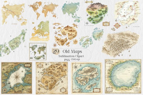
Old Maps Sublimation Clipart: A Versatile Creative Resource for Designers, Educators, and Small Businesses
Historical cartography has long captivated imaginations—not just for its geographic insight, but for its layered storytelling. Hand-drawn coastlines, ornate compass roses, faded trade routes, and decorative borders speak to centuries of exploration, speculation, and craftsmanship. Today, that same evocative power is accessible in digital form through Old Maps Sublimation Clipart: a curated collection designed not as static decor, but as a functional, adaptable asset for creators across disciplines.
What Makes These Files Distinct from Generic Vintage Map Graphics?
Not all vintage-style map assets are created equal. The Old Maps Sublimation Clipart set stands apart due to its intentional technical and aesthetic specifications—each chosen to support real-world production needs. Comprising 29 high-resolution PNG files, every image features a transparent background, eliminating the need for time-consuming manual masking or layer adjustments. This transparency is essential for sublimation printing, where designs must cleanly overlay onto colored or textured substrates like ceramic mugs, polyester fabrics, or coated aluminum panels.
Resolution is another key differentiator. Unlike low-DPI web graphics that pixelate when scaled, these files maintain crisp detail at print sizes up to 12×16 inches—sufficient for large-format canvas prints or detailed embroidery transfers. More importantly, the artwork avoids over-digitized “clipart sterility.” Each piece retains subtle grain, ink bleed, and paper texture cues—authentic visual signals that resonate with audiences seeking tactile, human-made aesthetics in an increasingly algorithmic design landscape.
For Print-on-Demand Entrepreneurs and Makers
Small business owners leveraging platforms like Etsy, Redbubble, or Printful benefit directly from the commercial-use license embedded in the Old Maps Sublimation Clipart package. Because redistribution or resale of raw files is prohibited—but derivative use is fully permitted—entrepreneurs can confidently integrate these elements into original product lines without legal ambiguity.
- T-shirts and hoodies: A weathered Mercator projection centered on the Atlantic Ocean becomes a conversation-starting chest print for history teachers or travel bloggers.
- Mugs and plates: A simplified 17th-century portolan chart, resized and paired with minimalist typography, lends sophistication to café merchandise or gift shop inventory.
- Backpacks and tote bags: A cropped section of a colonial-era coastline, repeated as a subtle all-over pattern, offers heritage appeal without overwhelming visual weight.
The instant-download format further supports agile workflows: no waiting for physical proofs or shipping delays means faster iteration, seasonal product launches, and responsive adaptation to trending topics—like commemorating maritime anniversaries or regional heritage months.
For Educators and Curriculum Developers
In classrooms spanning geography, history, literature, and art, primary-source visuals deepen engagement far beyond textbook reproductions. Teachers using the Old Maps Sublimation Clipart set report improved student retention when comparing historical boundaries (e.g., shifting colonial claims in North America) alongside modern political maps. Because each file is transparent and resolution-independent, educators can layer them in interactive digital presentations—zooming into marginalia, annotating sea monsters, or tracing migration paths with digital pens.
More creatively, students use the clipart in project-based learning: designing museum exhibit mockups, building annotated digital atlases, or crafting historically grounded greeting cards for cultural awareness units. The commercial license even permits schools to sell student-designed merchandise—such as limited-run “Explorers’ Guild” hoodies—as part of fundraising initiatives, reinforcing both design literacy and entrepreneurial thinking.
For Crafters and DIY Enthusiasts
Hobbyists find flexibility in how deeply they engage with the material. Some use the files as-is—printing directly onto iron-on transfer paper for custom aprons or pillowcases. Others treat them as foundational layers in mixed-media work: combining scanned parchment textures, hand-lettered captions, or watercolor washes over the printed base. Scrapbookers appreciate the lack of white borders, allowing seamless integration into layered layouts; digital planners gain thematic cohesion when navigation icons or section dividers draw from the same cartographic vocabulary.
Importantly, the prohibition against sharing original files protects both the creator’s intellectual labor and the user’s investment. When a crafter modifies a map fragment into a unique monogram or embeds it within a hand-drawn botanical border, the resulting work remains wholly theirs—free from attribution requirements or licensing entanglements.
Technical Considerations for Optimal Use
While the Old Maps Sublimation Clipart set is built for accessibility, successful implementation depends on understanding a few foundational principles:
- Color mode matters: Sublimation printers rely on CMYK color profiles, but most digital design software defaults to RGB. Always convert final compositions to CMYK before exporting for print—especially critical when preserving the muted ochres, slate blues, and sepia tones characteristic of aged maps.
- Scale with intent: High resolution doesn’t eliminate the need for thoughtful sizing. A full-world map at 300 DPI may exceed printer memory limits if used at full size on a 24×36 inch canvas. Instead, crop strategically—focus on a compelling region, then scale to fit your substrate dimensions.
- Transparency isn’t always invisible: On dark or metallic substrates, semi-transparent elements (like faint grid lines or light ink bleeds) may require slight opacity boosts or underlying white underbase layers—particularly in heat-transfer applications where substrate color affects perceived contrast.
These aren’t limitations—they’re opportunities for deeper craft. Understanding how ink interacts with fabric weave, how ceramic glaze affects tonal depth, or how vinyl cutting tolerates fine line work transforms the Old Maps Sublimation Clipart from decoration into dialogue between medium and message.
Ethical and Sustainable Creative Practice
In an era of AI-generated “vintage” aesthetics—often divorced from historical context or cultural nuance—the Old Maps Sublimation Clipart collection reflects a more grounded approach. Its imagery draws inspiration from documented public-domain sources, avoiding appropriation of Indigenous cartographic traditions or colonial propaganda presented uncritically. That intentionality extends to usage: because the license discourages bulk redistribution, it supports sustainable creative ecosystems—where value accrues to those who invest time in thoughtful adaptation rather than mass replication.
This aligns with broader shifts in maker culture: toward slower, more intentional creation; toward honoring material history while reimagining its utility; toward tools that empower rather than constrain. Whether a researcher illustrating a lecture on pre-modern navigation, a small-batch ceramicist stamping antique compass motifs onto handmade tiles, or a homeschool parent designing a world-history unit study—the Old Maps Sublimation Clipart serves as both artifact and catalyst.
Integration Into Broader Design Systems
Designers increasingly think in systems—not isolated assets, but interconnected components. The Old Maps Sublimation Clipart functions exceptionally well within such frameworks. Its consistent stylistic language (hand-drawn linework, restrained palettes, balanced negative space) allows seamless pairing with complementary resources: vintage typefaces like Caslon or Garamond, archival paper textures, or even contemporary data visualizations rendered in analogous tones.
For branding professionals, this coherence enables cohesive identity development. A boutique travel agency might use one map fragment as a watermark across email signatures, another as a pattern on business cards, and a third—recolored and simplified—as a favicon. The shared visual DNA reinforces recognition without repetition, satisfying both aesthetic and strategic goals.
Ultimately, the strength of the Old Maps Sublimation Clipart lies not in nostalgia alone, but in its capacity to bridge eras: making centuries-old spatial thinking relevant to today’s communication challenges, production methods, and pedagogical priorities—all while respecting the integrity of both source material and end-user creativity.